


GEOLOGY AND PROSPECTING FOR HYDROCARBON RESERVES

Background. The mechanisms and routes of hydrocarbon migration in the South Caspian basin are considered.
Aim. Assessment of hydrocarbon migration routes in the South Caspian basin.
Materials and methods. Statistical generalization and classification of data and materials from reference literature, geological reports, field data, and published works.
Results. The conducted numerical modeling of hydrocarbon systems in the South Caspian oil and gas basin allowed the mechanisms of hydrocarbon migration in this region to be determined. These included mud volcanoes, whose eruptive channels served as those for hydrocarbon migration, as well as stretching cracks created by the formation of diapiric structures. Almost all deposits in the South Caspian basin are located in the areas of mud volcanism and are complicated by their eruptive channels.
Conclusion. This indicates the role of vertical migration of hydrocarbons in filling the reservoirs of the productive stratum. The modeling results show that the critical moment and migration of hydrocarbons from the Eocene, Maikop, and Diatom oil and gas source strata occurred towards the end of the Surakhani time (3 million years ago), i.e., during the formation of the upper section of the productive stratum. In the oil and gas source stratum of the Tarkhan-Chokrak age, the critical moment completed only by the end of the Akchagyl time (2.2 million years ago).

Background. The southern immersion of the Buzuluk depression remains one of the most promising areas of oil and gas production in the Orenburg region due to significant residual reserves and favorable characteristics of Devonian deposits. The deposits of this region are characterized by a complex geological structure, high gas factor (more than 1000 m3/t) and stable oil reserves, which requires the use of modern geological and technical solutions. Despite the relatively high level of knowledge, due to the complex structure and features of fluid dynamics, the development of mature deposits is accompanied by a number of challenges and remains relevant for further research.
Aim. Identification of spatial patterns of the distribution of the gas content of reservoir oils within the southern immersion of the Buzuluk depression.
Materials and methods. The results of geological and commercial research and development data were used as source materials. Methods of structural and geological analysis, comparison of the gas content and the tectonic position of deposits are applied.
Results. The values of the gas content of the Vorobyovsky horizon oil deposits (formation DIV) within the southern and central parts of the Buzuluk depression demonstrate significant variability. An analysis of the spatial distribution of the parameter showed the presence of a general trend of increasing gas content from the Bobrovsko-Pokrovsky shaft towards the Kamelik-Chagan structural zone. At the same time, the highest values (up to 902 m3/t) were recorded in individual deposits of the structural zone. However, the structural and tectonic analysis did not reveal a direct and stable relationship between the amount of gas content and tectonic confinement. The established patterns are rather local in nature and may be due to the combined influence of lithological, stratigraphic, tectonic, thermobaric and fluid dynamic factors.
Conclusion. A general trend has been established towards an increase in the gas content of reservoir oils towards the southern boundary of the Buzuluk depression. The data obtained indicate the multicomponent nature of the formation of abnormally high values of gas content.

Background. This article considers the evolutionary features of formation of the transitional complex in Eastern Ciscaucasia regarding the hydrocarbon prospects of the Karpinsky Ridge.
Aim. To research specific evolutionary features of the transitional complex in Eastern Ciscaucasia and to carry out its basin analysis to identify the main components of petroleum systems.
Materials and methods. Statistical generalization and regimentation of materials borrowed from reference literature, stock sources, field data, and published works
Results. In the research area, three potential hydrocarbon-bearing rocks were identified, associated with the deposits of the Neftekumskaya and Kultaisko-Demyanovskaya sections of the Lower Triassic, the Kizlyarskaya section of the Middle Triassic, as well as deeply buried Carboniferous deposits as a potential shale source rock.
Conclusion. An integrated analysis of well data, geochemical studies, and paleogeographic reconstructions served as the basis for forecasting the main elements of petroleum systems.

Background. Signs of oil and gas potential have been identified in the sedimentary cover of the northern rim of the Siberian Platform and the adjacent water area of the Laptev Sea. These signs indicate the presence of active generation and accumulation of petroleum systems. In addition to the established industrial oil and gas potential in the Permian section interval, the north of the Siberian platform is also associated with Riphean, Vendian, and Devonian deposits; however, drilling has not confirmed the productivity of these section intervals. The present study is aimed at assessing the oil and gas potential of the Khatanga-Lena region of the Siberian sector of the Russian Arctic and the southwestern part of the Laptev Sea. Their study within the framework of a single model can extend the understanding of the development of sedimentary basins and the petroleum systems included in their composition.
Aim. Identification of effective petroleum systems in the joint zone of the Siberian Platform and adjacent structures in the southwestern part of the Laptev Sea.
Materials and methods. Analysis of available published and stock information with the purpose of identifying elements of the assumed petroleum systems. Mapping of geochemical characteristics of potential oil and gas source rocks. Numerical simulation of petroleum systems and identification of effective zones of oil and gas generation. Quantitative assessment of the hydrocarbon potential of source rocks.
Results. Two effective petroleum systems have been identified in the joint zone of the Siberian Platform and adjacent structures of the southwestern part of the Laptev Sea. These include Lower Kozhevnik-Upper Kozhevnik and Upper Jurassic-Cretaceous systems.
Conclusion. The contribution of the Lower Kozhevnik-Upper Kozhevnik petroleum system to the oil and gas potential of the Anabaro-Khatanga region and the coastal part of the Laptev Sea is estimated at about five billion tons of hydrocarbons. The Upper Jurassic-Cretaceous system can provide up to 1.4 billion tons of hydrocarbons in the southwestern part of the Laptev Sea shelf, which makes it possible to associate high oil and gas potential with the water area.
GEOPHYSICAL METHODS OF PROSPECTING AND EXPLORATION

Background. The priority positions of Russian geology and geophysics have been reliably supported by large volumes of mineral resources of Eurasian proto-ocean/EAO from ancient Arctic to Middle East. This ocean bordered on all its sides by four other proto-oceans that were opened step-by-step to different sizes between Gondwana, Europe and Asia with Siberia (G-E-A).
Aim. Graviseismic modeling of the Earth’s crust as a basis for RTOE-determination of four tectonic (rifto-, thalasso-, oro-, & epeiro-genic) regimes and a five-oceanic geostrophe of the Earth with two circumpolar and three intercontinental oceans.
Materials and methods. Collection and integration of actual geological and geophysical data on the world’s petroleum and mineragenic provinces to carry out a four-segment (RT-TO-OE-ER) zoning of the Earth’s crust and a sequence stratification of four system tracts (UST-MST-DST-LST formations) taking into account global fluctuations (up, max, down, low/min) of the sea level.
Results. Graviseismic identification of eight geostrophic plates of the modern Earth’s crust with its four-segment zoning and seismo-geological stratification into 12 global sequences.
Conclusion. A new graviseismic concept of a five-oceanic geostrophe of the Earth’s crust has been developed, which is capable of elucidating both past and future stages of the tectono-stratigraphic evolution of sedimentary provinces since the origin of the World Ocean.

Background. The study of temporal variations in the Earth’s gravity field is a pressing challenge in modern geophysics, particularly in the context of analyzing the impact of external and internal factors on the gravity force. Conventional approaches to modeling the gravity field are based on predefined theoretical assumptions, which limits their applicability under conditions of high variability of geodynamic processes.
Aim. To develop and test an innovative approach to constructing mathematical models of temporal gravity field variations, which employs empirical data and a phenomenological description of random processes rather than relies on predefined theoretical frameworks.
Materials and methods. The experimental part of the study was carried out at the Ledovo fundamental gravity station using a set of gravimeters of various types. Instrumental measurements of gravity variations were performed. The collected data were analyzed using spectral and statistical methods and Fourier transforms. Special attention was given to comparing readings recorded by different instruments. Additionally, an optimal linear smoothing procedure (OLSP) was applied to construct a generalized model of gravity field variations.
Results. The analysis revealed a high degree of consistency between measurements: the correlation coefficient between GNU-KV and CG-6 gravimeters exceeded 0.9, confirming the similarity of their spectral characteristics and the reliability of the recorded data. At the same time, the study showed that an unambiguous mathematical description of gravity variations is complicated by the influence of poorly understood geodynamic and random factors. The model based on OLSP enables the integration of elements from known theoretical models with consideration of “guest” processes, i.e., external and local factors of uncertain nature that affect the observed gravity variations.
Conclusion. The proposed model-free approach, along with the use of the optimal linear smoothing procedure, offers new possibilities for a more accurate and flexible description of temporal gravity field variations. The developed methodological approach may prove valuable in further geophysical research and in advancing methods for monitoring changes in the Earth’s gravity field.
GEOLOGY

Background. Paleoecology, which studies the reconstruction of ecosystems of the geological past and their temporal development, has occupied a key place in the complex of geological sciences. Theoretical and applied geology are increasingly incorporating the results of paleoecological analysis, primarily for facies analysis, paleogeography, and detailed stratigraphy.
Aim. To study the first discovered imprints of crinoid stem fragments on the epitheca of rugose corals and elucidate their paleoecological significance.
Materials and methods. More than 2300 corallites were macroscopically examined. The detected imprints of crinoid stem segments were studied using a binocular microscope MBS-1.
Results. A new form of preservation of crinoids has been established, represented by their segment imprints on the epitheca of rugose corals.
Conclusion. The revealed mechanism of formation of crinoids segment imprints on the epitheca of rugose corals indicates a calm hydrodynamic environment and allows us to confidently determine the position of the corallite on the ground.
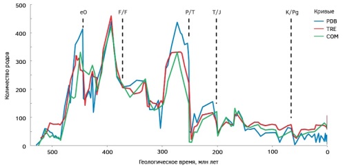
Background. Brachiopods evolved throughout the Phanerozoic, and their study contributes to the knowledge of the largest biotic crises. Accumulation and revision of paleontological information require regular re-evaluation of the influence of these crises on the taxonomic diversity of the given group of marine organisms.
Aim. To study the dynamics of the generic diversity of brachiopods under the influence of the most famous mass extinctions of the Phanerozoic based on three datasets representing different “generations” of paleontological compilations.
Materials and methods. On the basis of each dataset, a curve of generic diversity of brachiopods is constructed. Three curves are drawn against the uniform geological time scale. For the periods of mass extinctions considered, a decrease in the number of genera and relations to the preceding and forthcoming trends of diversity changes are estimated.
Results. The constructed curves indicate that the end-Ordovician, Permian/Triassic, Triassic/Jurassic, and Cretaceous/Paleogene mass extinctions triggered a decrease in the generic diversity of brachiopods. The largest was the influence of the Permian/Triassic catastrophe. Conversely, the effect of the Frasnian–Famennian (Late Devonian) event was either minimal or absent. The trends of diversity changes before and after critical intervals showed a different dynamic.
Discussion. The retrospective analysis of the curves of brachiopod generic diversity showed that newer information may have indicated a higher or lower intensity of crises in different cases. Moreover, the changes of the “generations” of paleontological compilations did not contribute to an improved understanding of the dynamics of the considered genera. Therefore, the three curves should be used in combination, treating the difference between them as the degree of error.
Conclusion. The results obtained indicate the vulnerability of brachiopods to mass extinctions, although to a different extent. Moreover, some estimates remain uncertain, which substantiates further research into of the development of brachiopods during the critical intervals of the geological history.

Background. African rift basins area characterized by changes from exclusively or predominantly gas to oil specialization, depending on the age of the deposits and moving away from the Southern and Western centers of the African superplume. A model accounting for changes in the conditions of hydrocarbon generation in peri- and intracontinental rift basins due to the cooling of asthenospheric rift-forming flows, upon their moving away from the hot plume centers, is proposed.
Aim. To determine regional geological patterns of the oil and gas specialization of rift basins and their probable nature.
Materials and methods. The study involved a comparative analysis of published data on the geology and oil and gas potential of rift basins (intra- and pericontinental) using seismic tomography data on the temperature state of the deep subsoil of Africa and the adjacent ocean areas.
Results. The oil and gas specialization of rift basins was shown to correlate with their age, tectonic development, and position in the modern structure of Africa, as well as with the distance from the Southern and Western centers of the African superplume.
Conclusion. The significant importance of the superplume in determining the oil and gas specialization of basins is substantiated.
GEOECOLOGY

Background. Throughout its history, the Vyazemsky District has been an area of particular importance not only for the Smolensk Oblast, but also for the entire Russian state.
Aim. To determine and evaluate geoecological risks in the Vyazemsky District of the Smolensk Oblast (Russia).
Materials and methods. Field studies and a detailed desk analysis of the processes and phenomena forming the geoecological risks in the area under study were conducted.
Results. A methodology for assessing geoecological risks was developed. Groups of events and phenomena forming geoecological risks were classified. The geoecological state of the Vyazemsky District of the Smolensk Oblast was evaluated. A geoecological assessment of significant hydrographic objects in the area under study was carried out. The resident population was described in terms of demographic and social characteristics. The impact of waste disposal facilities on the environment and public health of the region was analyzed.
Conclusion. The depletion of feeding and recreational landscapes, associated, inter alia, with the circulation of production and consumption waste, leads to sociopolitical risks. In the Vyazemsky District, geoecological risks have been undermining the sociopolitical stability of the region for a long time. Timely recognition and assessment of such risks and implementation of the respective measures will improve the sociopolitical stability of the region and mitigate the risks of man-made accidents and political upheavals.
GEOLOGICAL EXPLORATION TECHNIQUE

Background. Blast boreholes can be drilled using various drilling tools. The drilling efficiency of roller bits (up to 30 m per shift in Azerbaijan) is significantly higher than that of other drilling tools (10—15 m per shift), which explains their wider application.
Aim. To improve the technology of blast borehole drilling by applying hydromonitor bits with the purpose of increasing the drilling efficiency.
Material and methods. The process of blast borehole drilling was analyzed, with a focus on changes in the pressure in the borehole under the influence of a high-pressure jet flowing out of the nozzles of a hydromonitor roller bit. When solving the problem of increasing the drilling efficiency of such boreholes, attention is paid to the use of hydromechanical destruction of the borehole bottom.
Results. The conducted analysis showed that sharp changes in the pressure in rock pores lead to compression of the liquid contained therein. This creates a hydraulic shock, which expands the pore walls and destroys them. The introduction of a high-pressure jet of washing fluid in the borehole bottom contributes to improving the control of the drilling process.
HYDROGEOLOGY AND ENGINEERING GEOLOGY

Background. Specific features of conducting experimental filtration works in complicated hydrogeological conditions of intermittent water withdrawal are considered. The works were carried out at the Ergeninsky mineral water deposit, situated in the area of the junction of the Ergeninsky upland and the Volga River valley. Conclusions about the specific features of determining the aquifer parameters under these conditions are drawn; a review of the methods used for processing such pumps is provided.
Aim. Correction of the methodology of experimental filtration works under changing flow rate conditions.
Materials and methods. The groundwater reserves of the Ergeninsky mineral water deposit were revised based on the experience of geological exploration at the existing site of water withdrawal. In accordance with the technological scheme, the development of the deposit was planned in the mode of intermittent withdrawal. An experimental pumping from a weakly pressurized Ergeninsky horizon was carried out for three days in the operation mode, during which 10 stages of flow rate were identified. The determination of water transmissivity coefficient was performed by the method of superposition according to the flow rate steps as a single abrupt disturbance traced by the given decrease in the given time. The level of groundwater was recorded by a pressure sensor, while the flow rate was recorded by a water meter. Pumping treatment was carried out by the method of temporary tracing. A single water intake was used. The data obtained were processed using the Microsoft Excel software.
Results. The influence of periods of incomplete restoration of the groundwater level on the reliability of calculations of the transmissivity coefficient by the method of intermittent water flow rate was investigated. The conclusion is formulated about the possible causes of significant fluctuations in the water transmissivity coefficient when processing experimental filtration data, as well as about the possibility of using this method when processing such data.
Conclusion. An assumption is made about the influence of the filtration area boundary of the third kind on the data obtained during experimental filtration works. This correlation is expressed by the influence of the trend (increasing or decreasing) in the change of water withdrawal on the results of calculating the water transmissivity of the Ergeninsky aquifer by the method of intermittent water withdrawal, which makes it unacceptable in these conditions. At the pumping stage with a high flow rate, the discharge inversion into the overlying horizon occurs, the results of which continue further with a drop in flow rate and is expressed by an increase in the level, rather than by its decrease, as expected.
ANNIVERSARY


ISSN 2618-8708 (Online)


