


NEWS

GEOLOGY AND PROSPECTING FOR HYDROCARBON RESERVES
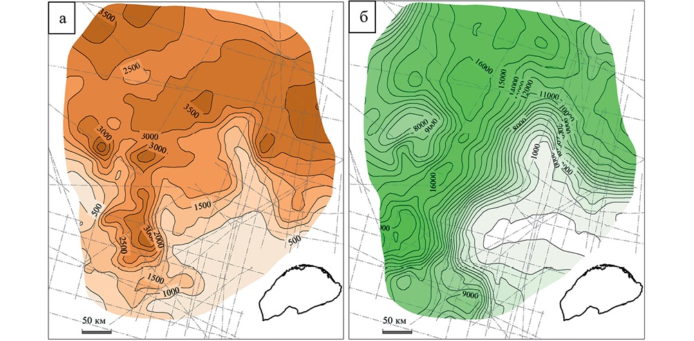
Background. According to retrospective data, the southern continuation of the North Chukchi Trough was considered low-prospective in terms of oil and gas deposits. Indeed, due to the poor and uneven geophysical exploration, the thickness of the sedimentary cover was estimated at 2—2.5 km. However, in 2018—2019, additional geophysical and geochemical surveys were carried out. New data has allowed an improved understanding of the structure of the southern continuation of the North Chukchi Trough and its oil and gas potential.
Aim. Study of the geological structure of the Umkilir basin as a continuation of the North Chukchi Trough to establish its oil and gas potential.
Materials and methods. Interpretation of 2D seismic surveys, potential methods, analysis of dynamic attributes, correlation of reflectors and faults, paleotectonic analysis, bottom samples, surface geochemical survey.
Results. The structure of the southern continuation of the North Chukchi trough, which is identified as an independent sedimentary basin Umkilir, is clarified. The main tectonic events and their age are established, the stratification of reflectors is carried out. Signs for the oil and gas potential of the basin are revealed based on seismic exploration and geochemistry data.
Conclusion. The Umkilir Basin was presumably formed in the Late Jurassic–Early Cretaceous after the end of the Cimmerian folding. It is composed of Mesozoic and Cenozoic SSC deposits separated by the regional Middle Brookian Unconformity. The sedimentary cover is complicated by transtensional and transpressional faults of submeridional vergence, to which amplitude anomalies in the Cenozoic SSC are confined. The oil and gas potential of the basin is also indicated by the presence of hydrotroilite in the bottom sediment, gas emanations in the water column, as well as by their chemical and isotopic composition.
Background. Challenge in developing wells with hard-to-recover reserves is monitoring the well’s near-wellbore zone, specifically, selecting operating modes that will ensure sufficient flow of hydraulic fracturing fluid, proppant, and hydrocarbon mixture without rock failure. Rock failure is the most unpredictable factor due to the low understanding of the processes in the near-wellbore zone. Rock failure results in the formation of varying sizes rock fragments. This rocks lead to deterioration or loss of well productivity by penetrating and filling the wellbore. The entry of rock into the wellbore leads to the risk of damage to wellhead equipment and clogging of well lines. It is important to identify which well testing modes cause the greatest stress on the pore space near the wellbore zone. After this, recommendations for well operation can be developed.
Aim. To identify conditions causing maximum stresses in the pore space near the wellbore wall, which can lead to its collapse. On this basis, to develop recommendations for safe well operation.
Materials and methods. The study was conducted using the results of core analysis, constructed geomechanical models, and actual flow rate/pressure measurements during well completion and production. Methods for calculating pore space collapse pressure along the wellbore were developed, including fragment transport calculations.
Results. The proposed approach ensures control over rock collapse pressure at any bottomhole pressure drawdown rate, minimizing collapse risks. This significantly reduces accident rates and operational complications during well completion and production.
Conclusion. The research analyzed extensive well completion and production data, investigating the causes of fragment generation. An original methodology for calculating permissible bottomhole pressures and optimal well operation modes was developed. Following implementation, no further incidents of rock collapse or surface fragment transport were observed. A program for further methodology refinement and scaling was established.
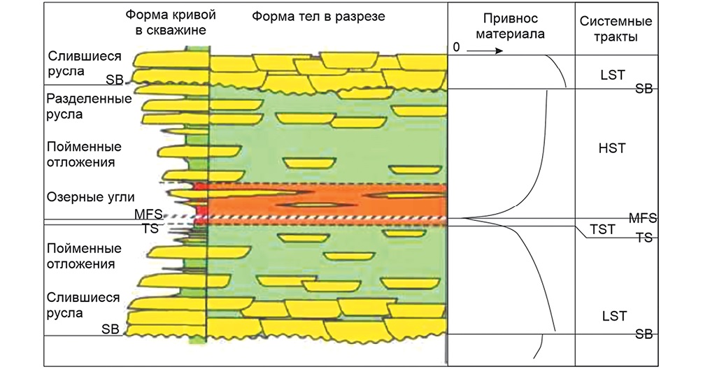
Background. We present the results of identifying promising objects (overlooked deposits) in well-studied fields under the conditions of lithologically heterogeneous reservoirs without disclosing the methodological principles of the developed approach in order to illustrate the possibilities of further work in mature fields.
Aim. To illustrate a promising direction in studying coastal-continental deposits with an extensive history of geological and geophysical studies with a focus on searching for local changes in lithology.
Materials and methods. Forecasting was carried out based on attribute values for the studied intervals with high correlation coefficients, as well as the values of gas-saturated and water-saturated thicknesses in wells. The available information was used to develop an algorithm of actions for identifying promising objects in areas with possible overlooked deposits. This algorithm allows the approach to identifying promising objects to be formalized and automated. A mathematical approach was used to determine the boundary value of the seismic attribute that records gas-saturated areas, which are independent of the structural factor.
Results. The results obtained by applying the tested method justify the complex lithological structure of the section under study and confirm the possibility of extending mature fields. The described approach represents a solution to the problem of searching for overlooked deposits in open fields of coastal-continental genesis associated with the lithological factor of trap formation.
Conclusion. The results can be used in the construction of 3D geological models to clarify the structure of sections. The application of the developed approach made it possible to identify overlooked lithological objects. The constructed maps of aggregated gas-saturated thicknesses will facilitate optimal location of transit wells to underlying deposits for the purpose of concurrent study of the section. The results obtained confirm the possibility of the existence of non-structural deposits in such sections.
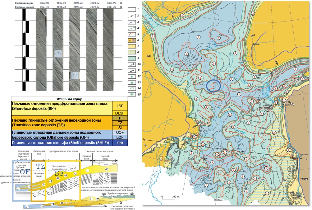
Background. The development of the hydrocarbon potential of the Sakhalin shelf is of strategic importance for the social and economic development of the Far East of Russia and its energy security.
Aim. Analysis and typification of mining and geological conditions favorable for the formation of hydrocarbon deposits in the Sakhalin shelf.
Materials and methods. Systematization of materials partially borrowed from reference literature, stock sources, field data, and scientific publications.
Results. The mining and geological conditions forming the sedimentary cover of the Sakhalin shelf exhibit a number of specific features due to its tectonic history, structural evolution, as well as lithofacies conditions. Local uplifts and anticlinal folds are associated with compression deformations, having resulted from a subduction of the Pacific Plate. Modelling results show that the complexes of the Cenozoic cover are located in the Sakhalin shelf and are conjugated into anticlinal folded structures of two types. The most striking difference between these two types lies in their striking patterns. Thus, some folded structures are sublatitudinal, and some are submeridional.
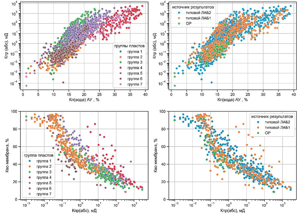
Background. In laboratory practice, the method of semi-permeable membranes using a batch porous plate is a conventional technique for determining irreducible water saturation (Swirr) and capillary pressure curves (CPC). The Swirr and CPC values obtained under ambient conditions in batch porous plates must be adjusted to reservoir conditions before they can be effectively applied in petrophysical, geological, and hydrodynamic models.
Aim. To investigate experimentally the effect of pressure and temperature on the measured values of Swirr and CPC when transitioning from ambient to reservoir conditions using the same core samples.
Materials and methods. By analogy with other previously completed works in various laboratory centers in related fields, our experiments included the sequential determination of water saturation and electrical resistivity of core samples under various combinations of effective confining pressure and temperature, using both a batch porous plate and an individual cell porous plate with semi-permeable membranes. In addition, we analyzed a comprehensive dataset on capillary pressure curves measured under ambient and reservoir conditions in different laboratories.
Results. A systematic decrease in the measured values of Swirr was observed in the individual cell porous plate compared to the batch porous plate. Under temperatures corresponding to ambient conditions, an increase in effective pressure led to a reduction in the observed Swirr values. The influence of temperature on Swirr could not be reliably determined.
Conclusion. The obtained results show discrepancies with the initial assumptions regarding the impact of experimental conditions on Swirr values. Further studies are required, and a revision of existing measurement approaches may be necessary for the studied objects.
Background. The strong heterogeneity, nanodarcy-scale permeability (1—100 nD), and nonlinear flow characteristics of unconventional low-permeability reservoirs result in negligible natural productivity, making hydraulic fracturing the only economically viable development method.
Aim. To address this challenge, the China National Petroleum Corporation (CNPC) has developed the proprietary FrSmart 2.0 solution based on 20 years of research, enabling geo-engineering optimization throughout the fracturing workflow.
Materials and methods. The software integrates nine synergistic modules, including the following. (1) Geomechanical Modeling constructs 1D—3D models using well-log and field data via finite-element algorithms. (2) Artificial Fracture Simulation employs non-planar 3D fracture modeling for complex scenarios (e.g., multi-cluster staged fracturing in horizontal wells). (3) Post-Fracturing Production Prediction leverages Embedded Discrete Fracture Modeling (EDFM) for accurate productivity forecasting and development optimization. (4) Real-Time Decision-Making dynamically analyzes stimulated rock volume (SRV) and fracture morphology using microseismic data. (5) Pre-Fracturing Design optimizes “sweet spot” intervals and cluster placement via entropy weighting and clustering algorithms. (6) Casing Deformation Risk Analysis evaluates fault stability using Mohr-Coulomb failure criteria. (7) Economic Evaluation offers lump-sum and itemized cost models. (8) The Diagnostic Fracturing Tests module determines closure pressure and fluid efficiency. (9) Database Management centralizes proppant, fluid, tubular, and rock mechanics parameters.
Conclusion. FrSmart 2.0 enables less than 5% deviation from international benchmarks and supports GPU acceleration. This software has been deployed at over 2000 workstations across 90% of Chinese oil and gas companies and universities. It has allowed optimization of over 18,200 stages/ intervals with 96% user satisfaction. Its integrated design, high-performance algorithms, and adaptability render FrSmart as a critical domestic solution for enhancing recovery in unconventional low-permeability reservoirs.
GEOLOGICAL EXPLORATION TECHNIQUE
Background. The development of gas condensate fields (GCF) using conventional depletion-based approaches is accompanied by the irreversible loss of significant amounts of condensate within the reservoir and a substantial decline in gas well productivity. Currently, the search for alternative approaches to developing this type of reservoirs, involving reservoir management techniques, is a high-priority objective.
Aim. Gas cycling is an approach for GCF development, involving reservoir management, which is widely and successfully applied in global practice. This approach aims to maintain reservoir pressure and vaporize hydrocarbons from the condensed liquid back into the dry gas that flows through the reservoir. In this work, we address the problem of designing and optimizing gas cycling by determining the fraction of dry gas to be returned to the reservoir, the start time of injection, and the injection duration — the parameters that govern the economic effectiveness of GCF development.
Materials and methods. A series of simulations were performed using a compositional reservoir model, with variations in the composition of the gas condensate mixture, the reservoir pressure at the start of injection, the injection duration, and the fraction of dry gas returned to the reservoir. An economic model to calculate the net present value for each injection scenario was created. A neural network model was trained and tested.
Results. Neural network technologies were used to develop an algorithm and a software program to select the optimal volume of gas reinjection, the start time of injection, and its duration. The steps include reproducing the results of the reservoir simulations and determining the scenario and parameters of gas injection that provide maximum economic efficiency of the gas cycling process under given economic conditions.
Conclusion. The developed algorithm and software program represent a tool for a prompt selection of the optimal gas cycling implementation option for given geological and physical characteristics of the reservoir, the composition and properties of the reservoir gas, as well as economic conditions. This option can be further elaborated in detail using a full-scale reservoir model during the design and management of the GCF development process.
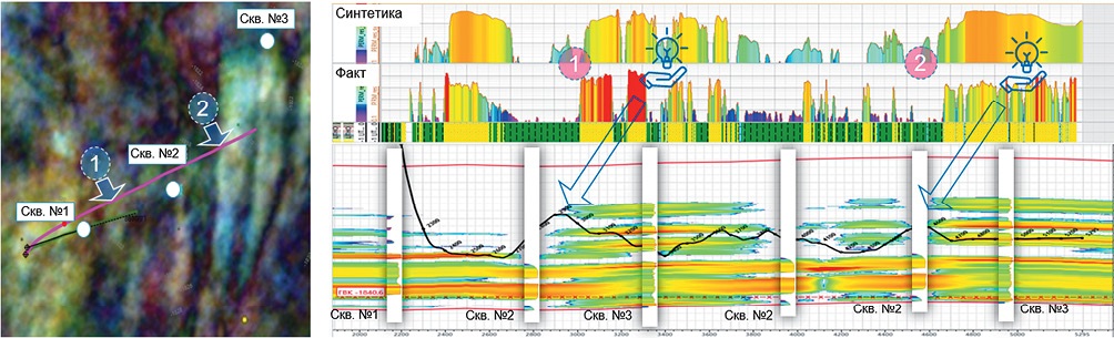
Background. In difficult lithological and facial conditions, the tasks of geological steering require improved approaches to constructing a geological section during drilling. The selected method should be prompt, detailed, and capable of flexible adjustment of the section properties based on information received during drilling.
Aim. To apply a geological simulation algorithm to reconstruct the properties of a section with a high lateral variability, enabling flexible adjustment of test wells and the required update rate in real time.
Methods. The problem was solved using the mathematical method of inverse distance weighting (IDW), i.e., a type of deterministic multivariate interpolation based on calculating values at unknown points using a weighted average of known points. The IDW method is effectively used to interpolate diverse data sets, including temperature, substance concentration, and other spatially dependent variables. This method was used to reconstruct the geological section under study without conflicting with seismic data. The results were compared with those obtained by alternative specialized 3D geophysical simulation programs.
Results. The approach of reconstructing a synthetic section along the actual wellbore was used. This approach meets the requirements of geological steering in terms of promptness and detail, providing a geological picture consistent with such a priori data as wellbore logs of the surrounding area and seismic attributes of the drilling area.
Conclusion. To mitigate the shortcomings of grid models and the DSC method, we used an algorithm to develop a reservoir model along the horizontal well of interest. The possibility of adjusting the influence of the test well during section formation allowed seismic data to be taken into account in the simulation process. High convergence of models constructed using the proposed approach and the kriging method is demonstrated, and their application to real data is demonstrated.
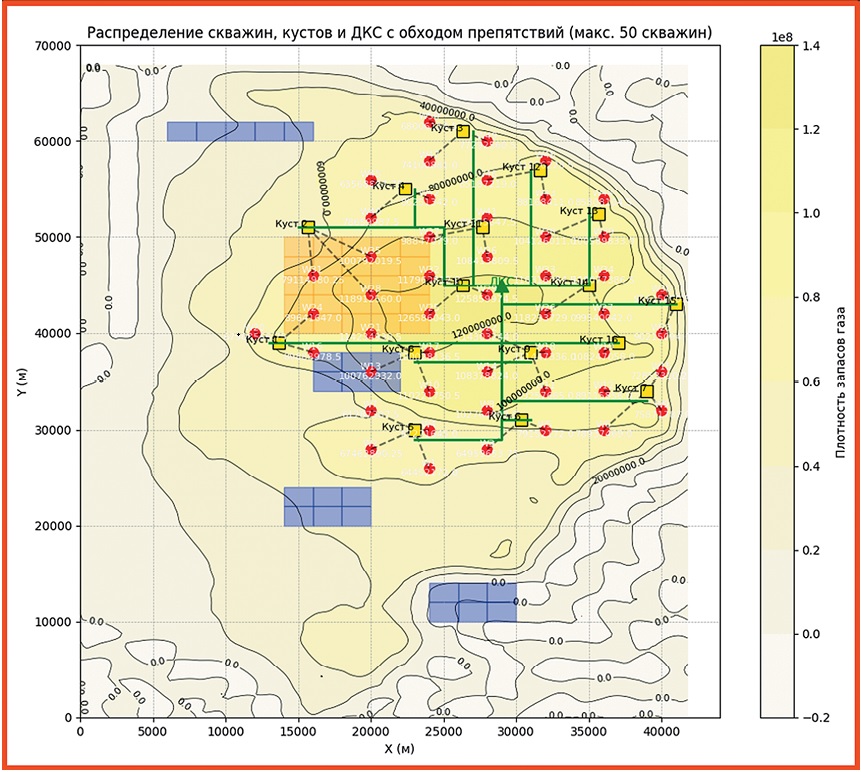
Background. Effective planning of gas and gas-condensate fields requires an integrated approach, which could ensure maximal economic effects while observing the conditions for the rational use of hydrocarbon reserves of the field. This includes not only effective technological solutions for field development, such as the number of wells and development systems, but also the optimal design of the entire infrastructure.
Aim. To develop a methodology for optimizing the placement of production wells, well pads, and booster compressor stations (BCS) taking into account technological, economic, and geographical constraints.
Materials and methods. The proposed approach is based on mathematical modeling, including an analysis of the density of reserves in the reservoir for the most competent placement of design wells, accounting for the costs of infrastructure construction and minimizing the costs of gas transportation. Additionally, landscape constraints affecting the placement of infrastructure facilities are considered.
Results. The developed approach allows the amount of hydrocarbon reserves involved in development to be maximized and the capital costs for infrastructure construction and operating costs to be minimized, which constitutes the key task of gas field planning. Conclusion. The developed methodology and its software implementation can be used in the design of new gas condensate fields, as well as for optimizing the development schemes of existing facilities.
Background. The Sakhalin shelf is one of the key oil and gas regions of Russia, where significant hydrocarbon reserves are concentrated. The main deposits are located within the Sakhalin shelf of the Sea of Okhotsk, including the North Sakhalin oil and gas basin and the East Sakhalin oil and gas region.
Aim. Analysis of geological exploration and development of hydrocarbon deposits in the area under study.
Materials and methods. Review of data and materials borrowed from reference literature, stock sources, field data, and scientific publications.
Results. Technological solutions, environmental, economic, and regulatory measures are recommended for geological exploration and development of hydrocarbon deposits.
GEOPHYSICAL METHODS OF PROSPECTING AND EXPLORATION
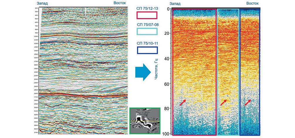
Background. This article describes the methodological principles of applying frequency-dependent balancing of seismic trace amplitudes to improve the quality and resolution of 3D reflection seismic survey data in severe surface and subsurface conditions, which are typical of the exploration area of the NOVATEK company. By using specific examples, the potential of the frequency-dependent approach to amplitude processing combined with 5D data regularization is demonstrated. This approach allows the data informativity to be increased and the geomorphological and sedimentological details to be obtained. Objective assessments of the reliability of expansion of the seismic signal spectrum using the neural network approach are presented, in comparison with the technology developed and implemented by the NOVATEK Scientific and Technical Center.
Objective. To determine the prospects of modern approaches to spectral and spatial processing of seismic data in the context of improving the quality and resolution of the results.
Materials and methods. The materials of methodologically non-homogenous archive and modern 3D reflection seismic surveys, processed using various (explosion, vibration, impulse) sources of wave excitation, were used. Data processing was carried out using the methods and approaches most contemporary at the respective period of time.
Results. The conducted analysis of the published results established their correctness in comparing seismic images, parameters, and attributes based on the data of the final migrated cubes of 3D reflection seismic surveys.
Conclusion. Frequency-dependent amplitude balancing is a theoretically justified and recommended method for application in the exploration area of the NOVATEK company. In combination with 5D regularization, this methodological approach creates the prerequisites for increasing the reliability of geological interpretation of seismic data and increasing the accuracy of the productivity forecast.
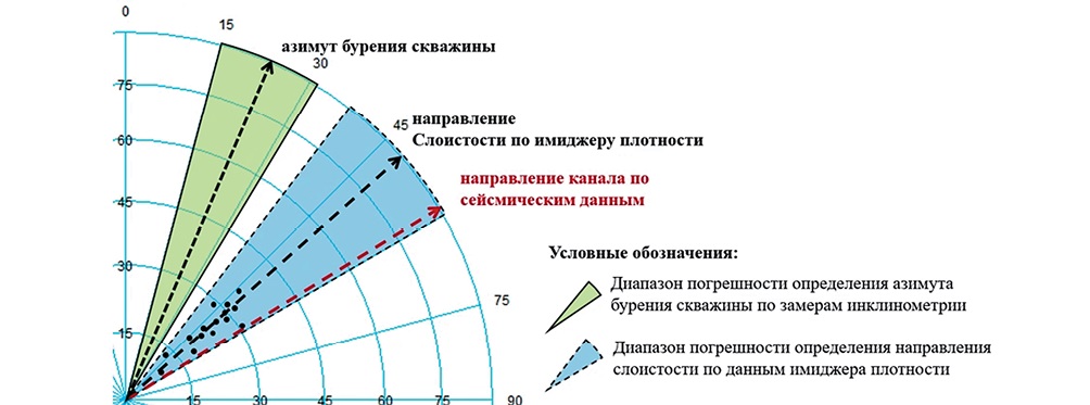
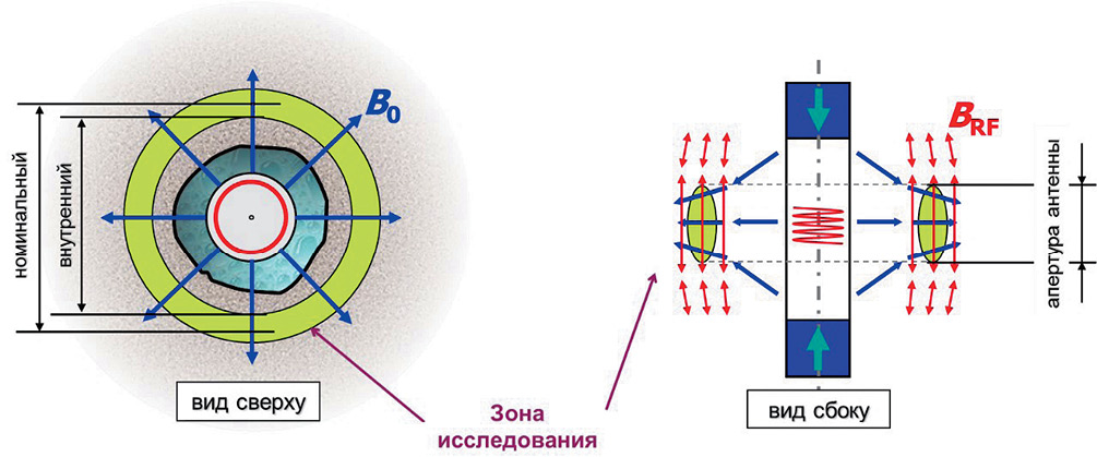
Background. Determination of paleocurrent directions is an important step in geological modeling. The primary objective of reconstruction consists in the textural analysis of bedding with the purpose of correlating the results with local flow direction. Bedding orientation and dip angles can be derived from density imager data.
Aim. To enhance the accuracy of oil and gas reservoir geological models and improve well placement efficiency during geosteering by implementing a methodology that integrates imager data, seismic data, and boundary mapper interpretations.
Materials and methods. The proposed algorithm incorporates density imager and boundary mapper data when carrying out geological modeling and well drilling. This algorithm includes structural interpretation of density imager data; classification of structural elements; interpretation of boundary mapper data; integrated analysis of density imager and boundary mapper results; synthesis with seismic data.
Results. The applied methodology increased effective drilling by 499 meters and successfully penetrated a fourth reservoir unit with high reservoir properties, thereby improving gas reserves characterization and volume estimation.
Conclusion. Boundary mapper data enable evaluation of the geometry of local geological bodies. Seismic data analysis is used to delineate boundaries and strike directions of geological features. However, the resolution limitations may hinder reliable stratigraphic correlation. An integrated analysis of density imager, boundary mapper, and seismic data clarifies facies trends, supporting updates to facies and geological models. Azimuthal bedding shifts during drilling may indicate transitions between geological units.
Background. In the development of low-permeability reservoirs with low-salinity formation water (Achimov formation, Western Siberia), the reliable assessment of formation saturation is a critical challenge. MagTrak™ Nuclear Magnetic Resonance (NMR) logging-while-drilling (LWD) technology provides the capability for continuous formation saturation determination while drilling. However, the influence of active ongoing filtration of oil-based mud (OBM) [4] on NMR-while-drilling data is insufficiently studied. The dynamic nature of the process, the shallow depth of investigation capabilities of LWD tools, and drill string vibrations create unique challenges for interpretation of formation saturation from NMR data.
Aim. Determination of the saturation of Achimov deposits using the NMR method while drilling.
Materials and methods. The materials used included data from nuclear magnetic resonance (NMR) logging while drilling pilot holes.
Results. Data on formation saturation were obtained during the drilling process using nuclear magnetic resonance logging. During the NMR investigations, the influence of oil-based mud was identified.
Conclusion. Positive experience was gained in applying NMR while drilling to assess formation saturation in the conditions of low-permeability Achimov deposits, taking into account the influence of oil-based mud (OBM). This work presents an approach using NMR recordings: both while drilling and after drilling while pulling out the drilling assembly.
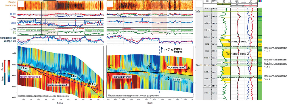
Background. Drilling horizontal wells into Jurassic formations in Yamal-Nenets Autonomous Okrug (YNAO) fields involves faults intersection [5]. In such cases, horizontal section geosteering strategy after crossing a fault is based on an assessment of the wellbore’s stratigraphic position and the technical capabilities available to ensure the geological objectives achievement [7]. Traditional methods for predicting faults intersection depth are rely on seismic data, while identification during drilling is based on logging data. The existing logging data depth of investigation limitations makes the task of identifying a fault and determining the wellbore’s stratigraphic position after crossing it quite complicated. As a result, decision on the subsequent steering maneuver presents significant uncertainty.
Aim. Estimate how advanced logging while drilling methods such as high-resolution multilayer mapping while drilling service complement existing fault identification techniques [2].
Materials and methods. This study based on actual drilling data from Jurassic reservoirs. It will demonstrate examples of how using deep boundary mapping tools (resistivity-based) helps to achieve the objective of identifying faults, determining the wellbore’s stratigraphic position and detecting reservoir thin sublayers within the tool’s depth of investigation in the formations of the X field.
Results. The application of deep resistivity boundary mapping technology in Jurassic formations (enabled by the resistivity contrast between shale and reservoir layers [8]) significantly enhances, and often makes fundamentally possible, the determination of the wellbore’s position within the stratigraphic section after crossing faults. This enables more confident stratigraphic correlation and allows for trajectory optimization to achieve the pre-defined geological objectives.
Conclusion. Comparison of the resistivity inversion with other logging methods demonstrates a high degree of reliability in the data acquired while drilling and its interpretation (azimuthal imaging while drilling, borehole acoustic reflection survey). Combination of multiple approaches and different measurement types can provide even greater insight into the subject of study.
GEOECOLOGY
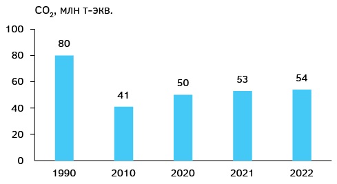
Background. Climate change is a serious global issue. In 1992, with the purpose of mitigating its effects, the UN Framework Convention on Climate Change was adopted. The subsequent steps were the Kyoto Protocol (1997) and Paris Agreement (2015). Currently, this problem has reached a critical level, requiring additional efforts.
Aim. Assessment of the activities carried out in the energy sector of Azerbaijan to fulfill its obligations under the Kyoto Protocol and Paris Agreement.
Materials and methods. The fulfillment by the Republic of Azerbaijan of its obligations under the Kyoto Protocol and Paris Agreement is analyzed based on the dynamics of greenhouse gas emissions since 1990. The results of the measures taken are evaluated.
Results. The period after the Paris Agreement has shown the impossibility of maintaining the global temperature increase below 1.5°C, thus requiring implementation of stricter measures. The 29th Conference of the Parties to the Convention on Climate Change held in Azerbaijan demonstrated that developed countries do not intend to intensify their efforts. This is evidenced by adding one more day to the schedule of the conference, assigned to solving the financial issue. Conclusion. The firm position of the Azerbaijani side and the support of the non-aligned states forced the developed countries to approve the allocation of the necessary financial support.

ISSN 2618-8708 (Online)


