


GEOLOGY
Background. Large-scale geological structures, such as lineaments, are of great research interest due to their potential to mark the presence of ore fields.
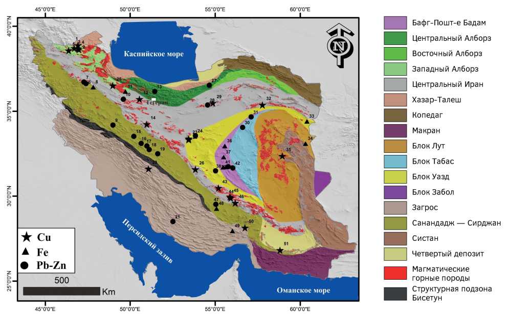
Aim. To determine the relationship between ore deposits, lineaments and large-scale faults in Iran using satellite imagery, digital relief modelling and structural mapping.
Materials and methods. In this study, we compiled a map of lineaments in the Iran, which were determined both automatically and manually. A database of the distribution of ore deposits and lineaments was compiled from available maps, publications and reports on ore deposits in Iran. These maps were overlaid to study the relationship between the locations of the lineaments, faults and ore deposits.
Results. An analysis of the lineaments revealed on geological maps indicates the presence of four dominant strike directions of large and small lineaments. The developed lineament map shows the main northwest trending longitudinal faults, which are parallel to the main strike of the Zagros orogenic belt; sublatitudinal and submeridional trending oblique faults; northeast trending transverse faults. A “Combined map of lineaments and deposits of copper, lead, zinc and iron in Iran” was compiled by the ArcGis software using maps of lineaments and mineral deposits. The ore deposits identified were analysed to determine the distribution of the distances between each deposit using the counting and cumulative methods the ArcGis software.
Conclusions. About 90% and 50% of ore deposits are located at a distance of less than 15 km and 5 km, respectively, from the centre line of the associated lineament. A direct relationship between the density of lineaments and the presence of deposits was observed. The obtained results demonstrate the potential of this method for assessing the prospects of ore fields in hard-to-reach and poorly studied regions.
GEOLOGY AND PROSPECTING FOR SOLID MINERAL DEPOSITS

Background. Experimental exploitation of ores from the Sukhoi Log deposit has shown that its geology and structure requires elucidation.
Aim. To study the geology and structure of the Sukhoi Log deposit and to determine the main mineralisation patterns in the plan, on the flanks and at depth. This information can be useful when mining gold both directly at the deposit and when prospecting new deposits on its flanks.
Materials and methods. The existing maps, diagrams, sketches and block diagrams describing ore bodies and their behaviour in plan and at depth were used. A new structural layout of mineralisation at the Sukhoi Log deposit, both on its flanks and at depth was built.
Results. The gold mineralisation in the Sukholozhskaya and Verninsko-Nevskaya ore-bearing areas is controlled by various elements of the fracture structure. At the same time, in the Sukholozhskaya area, the mineralisation is confined to a thick zone of a sublatitudinal shingled thrust-fault zone, in places accommodating a narrow strip of small faults, slip planes and fracturing in the northwestern direction. The fracture strip intersects sub-latitudinally laying Riphean argillaceous-shale rocks of the Khomolkhin formation approximately in the middle part of the field. The shingled thrust-fault zone accommodates the fissure faults, which open during mineralisation of the north-west extension, and flattens out. Its thickness in some places reaches 130 m. In the curved and flattened thrust interval, an ore gold-arsenopyrite-pyrite-quartz formation is localised, morphologically resembling a “thick pillow” with a thickness of 130 m. It bends and gently plunges in the north-north-east direction. The bulk of gold reserves is contained in this ore formation. The ores of the vein-disseminated type, veinlet and vein formations are the richest formations. Between them, the dissemination of gold-bearing pyrite and subordinate arsenopyrite is always manifested. The boundary of industrial mineralisation is determined by the density of the interveinous ore.
On the western flank of the deposit, within the bounds of another — Ugakhan — deposit, vein and vein gold-quartz-pyrrhotite ores are found at a deeper level. Here, the search for Sukholozhsky pyrite-quartz ores (if they even existed) is not promising, since they were eroded long time ago, and the liberated gold was concentrated in placers. Prospecting is promising only along the Bezymyanny ore-controlling fault, which directly limits the western flank of the Sukholozhskoye deposit.
The mineralisation of the Verninsk-Nevsky area is controlled by the Verninsky Fault of the east–north-east extension and separated by a series of single feathering ore-bearing overthrust zones of the east-west extension. To the east, this mineralisation gradually decreases. The search for the Sukholozhsk type ores is more promising on the eastern side of the Nyrli river, 2 km east of the fault of the same name and 7 km north of the Verninskoye deposit near a small, poorly explored area with commercial gold mineralization, marked on the deposit map with a sign TM.
Conclusion. The main geological and structural laws of the localisation of gold ores were determined, which could be useful when conducting exploration works on the flanks of the deposit.

Background. The Novo-Uchaly copper-zinc VMS deposit in the Southern Urals (54°10΄54˝N and 59°20΄45˝E) is represented by a steeply dipping lens of Eifelian volcanics (rhyodacites and basalts), which are crumpled into a strongly compressed anticlinal fold. The ore deposit is blind and localised at the convergence of felsic (bottom) and mafic (top) rocks. The deposit is located at depths of 550 m (in the northern part) and 1050 m (in the southern part). The deposit thickness reaches 186 m. The length along the strike and along the dip equals 1250 m and 900 m, respectively. The ore body is intruded by gabbro-diorite and gabbro-diabase dikes. The main ore minerals are pyrite, sphalerite and chalcopyrite, as well as non-metallic minerals, such as quartz, barite and calcite. Unlike most of the Ural VMS deposits, this deposit is the zinc subtype (Zn >> Cu). The ores are predominantly massive and solid sulphide, being banded or brecciated in some parts. The main elements extracted are copper, zinc and sulphur, but gold, silver, cadmium, indium, cobalt, nickel, selenium and tellurium are also obtained.
Aim. To clarify the morphology of the ore deposit, to study the ore mineral composition of the upper horizons of its northern part and to determine the underlying reasons for the complex lenticular structure of the sulphide reserve.
Materials and methods. In the period 2017—2019, employees of the Institute of Ore Deposits, Petrography, Mineralogy and Biochemistry of the Russian Academy of Sciences (IGEM RAS) together with geologists of the Uchaly Mining and Processing Plant carried out a geological and mineralogical mapping of the deposit in the course of exploration works.
Results. The ore contours and mineral composition of the northern part of the ore body were significantly clarified. A series of dikes of variable morphology was identified. A comparison was made of the results with current theories about the structure of the ore deposit. Detailed geological sections were determined and illustrate the complex lenticular structure of the ore deposit complicated by pinch and swell areas. The deposit was formed by processes of dynamic metamorphism.
Conclusion. The geological and mineralogical structure of the deposit determined in the study enabled us to propose a schematic reconstruction of the conditions leading to the formation of its folded structure. The findings will help to re-assess the reserves and improve the system of operational exploration and delineation.
GEOLOGY AND PROSPECTING FOR HYDROCARBON RESERVES

Background. The Astrakhan-Primorsk region of oil and gas deposits located in the North Caspian region is one of the world’s largest reserves of hydrocarbons. This region stretches from land in the northwestern part of the Caspian basin, through the northern waters of the Caspian, to the south-eastern land part of the region under consideration.
Aim. To identify geodynamic and geological factors in the formation of large hydrocarbon deposits in subsalt sediments in the complex structure of the North Caspian region of the Caspian syneclise. Materials and methods. An analysis of data on the geodynamic and geological evolution of the North Caspian region of the Caspian syneclise revealed specific features of its geological structure and development.
Results. The nature of the formation series, as well as the geodynamic and geological conditions (the presens of spreading and subduction zones that caused an intense heat flow, the presense of an isolated sedimentation basin with intensive accumulation of carbonates in the Upper Devonian-lower Permian, a powerful salt-bearing Kungurian cap) were favourable for the generation, migration and accumulation of hydrocarbons in large tectonic-sedimentary Upper Devonian–Lower Permian uplifts characteristic of the Astrakhan-Primorsk oil-and-gas bearing region of the North Caspian. These uplifts were formed by shelf bioherms, barrier reefs and large reeftogenic atolls and emerged through ancient troughs. The large hydrocarbon accumulations, such as Kashagan, Tengiz, Astrakhanskoye and Korolevskoye, with high specific hydrocarbon reserves (more than 100 thousand/km2) are associated with these troughs.
Conclusion. During the Upper Paleozoic, the main paleodepressions of the isolated basin of the North Caspian underwent a steady and long-term subsidence process, favourable for the accumulation of a thick stratum of carbonate (mainly reef) formations. This period was also characterized by the geothermal and baric conditions necessary for the transformation and subsequent migration of hydrocarbons from oil- and gas-producing complexes to reservoirs, which were mainly presented by massive carbonate formations of reef genesis. The as-formed deposits were preserved by thick salt-bearing Kungurian sediments. Directions for prospecting and exploration works aimed at discovering new hydrocarbon deposits in the subsalt sediments of the region were outlined.
GEOPHYSICAL METHODS OF PROSPECTING AND EXPLORATION

Background. In the process of studying productive Domanik deposits of the Frasnian-Famennian, numerous uncertainties arise in identifying their effective thickness. Although several approaches have been recently proposed for identifying promising intervals in Domanik sediments, e.g. determination of the effective thickness using gas logging during geological and technical studies, the use of the interpretation method presented in the article and other methods continue to develop. Therefore, studies aimed at increasing their efficiency remain to be relevant.
Aim. To develop basic methodological approaches to interpretation of well logging data with the purpose of identifying promising Domanik deposits rich in mobile hydrocarbons.
Materials and methods. Geological and geophysical data obtained when investigating the wells of the according to published data of geological and geophysical resources of drilled wells in the Buzuluk depression were used to build the main well logging dependencies. In addition, the materials of core and geophysical studies of wells in the Volga-Ural oil and gas basin conducted by Gazprom Neft (PJSC) were used. Extended well logging data were collected for the wells under consideration. A number of tests and core studies, including geochemical experiments, which were carried out in deposits of Fran age, the density of resources of 5—10 samples per 1 meter of core.
Results. For the first time, basic methodological approaches for identifying effective oil-saturated strata in Domanik sediments according to well logging data were developed. The developed approaches are based on the integration of geological-geophysical and geochemical data characterizing the material and mineralogical composition of rocks, the content of organic matter, the group composition of hydrocarbons and the genesis of reservoirs. In the section under study, rocks saturated with hydrocarbons were identified. The hydrocarbons were different in terms of group composition, which determined their mobility. Boundary values were obtained when interpreting data obtained by well logging methods for Domanik rocks containing mobile and stationary hydrocarbons. The proposed methodological approaches were tested on other wells in the Domanik deposits in the Orenburg region. As a result of repeated practical application and testing of the developed methodology, its effectiveness was confirmed.
Conclusions. The proposed basic methodological approaches for interpretation of well logging data when identifying effective oil-saturated strata were substantiated by the geological-geophysical and geochemical properties of Domanik deposits.
MINERALOGY, PETROGRAPHY, LITHOLOGY

Background. Complex Au-Cu-U mineralization is found in the metamorphic rocks of central Vietnam in the zones of their contact with Triassic granite intrusions. It is localized in tectonic breccias and cataclasites, which affected Triassic granitoids and Precambrian metaskarn rocks. The greatest differentiation is observed for tectonically disturbed granites of the Hai Van complex and the metasomatically reworked zones of contacts of this complex with metacarbonate and metaultramafic rocks of the Kham Duc complex.
Aim. To determine the mineral and elemental composition of complex occurrences of Cu, U and Au in Proterozoic rocks of the Kon Tum province of central Vietnam.
Materials and methods. The work was based on the authors’ data obtained during fieldwork and analytical laboratory studies in the 2016–2019 period. The diagnostics of ore mineral composition was carried out using 60 polished sections. The chemical composition of ores was determined for 214 samples by ICP MS and for 374 samples by atomic absorption spectrometry at the Vietnamese Centre for Geological and Experimental Analysis in the city of Hanoi. The geochemical relationships of ore components were established by the method of multivariate statistical correlations.
Results. The mineral composition includes pyrrhotite, pyrite, chalcopyrite, molybdenite, magnetite, martite, hematite, cubanite, marcasite, gold, xenotime, sphalerite, uraninite, chalcocite, covellite, goethite, malachite and limonite. According to the petrographic and petrochemical composition, the geological position and the data on isotopic age, the metamorphic formations of the Kham Duc complex can be considered as Neoproterozoic-Cambrian formations having experienced metamorphism in the Ordovician.
Conclusion. A scheme of the sequence of mineral formation was outlined. ICP MS results of primary ores showed that, in addition to Cu, the formations under study contain concentrations of Co, Mo, U, Au, Zn, Ni, V, Y, La, and As. A positive correlation was found between Cu, U and Au. A model of hydrothermal ore formation was proposed.
GEOLOGICAL EXPLORATION TECHNIQUE

Background. Various approaches are currently used to create borehole curvature depending on associated methodological and practical geological problems. Continuous action whipstockes are considered to be the most modern and accurate among these approaches. The efficiency of such devices may decrease under difficult mining and geological conditions.
Aim. To increase the efficiency of drilling a curved borehole in hard and very hard rocks by reducing the speed of drilling out an artificial bottom.
Materials and methods. We studied the operating principles of various types of continuous action whipstocks. Empirical results were determined by studying the operation of continuous milling whipstocks in difficult rock conditions and by studying the materials used for manufacturing artificial bottom holes. The study included optimization of the efficiency of drilling a well in hard rocks from an artificial bottom hole in a new direction.
Results. The main factors decreasing the whipstock efficiency were found to be the mechanism of buildup rate, and the different strength of the rock and artificial bottom-hole. A feature of the work of a milling type whipstocks is that the creation of a deflecting force is carried out due to the constant influence of the axial load, the value of which proportionally affects the speed of drilling. A review of the materials used to create an artificial bottom led to the conclusion that at present there are no curable materials that would have a hardness higher than category 8 for drillability, which means that when trying to drill a new direction of a well in rocks more than 8 grade for drillability, the speed drilling with a continuous action whipstocks will exceed the optimum and reduce the intensity of the buildup rate whipstock.
Conclusion. Since the rate of drilling an artificial bottom hole is difficult to regulate using the drilling mode parameters, it is necessary to develop technical solutions that would limit the rate of deepening a new direction of the wellbore.
CHRONICS

CRITICS AND BIBLIOGRAPHY

ISSN 2618-8708 (Online)


