


GEOLOGY

Background. For a long time, deep deflections present in the Arctic basin seafloor have been a site for accumulating a thick sedimentary cover and a subsidence epicentre. Issues associated with the geological structure and tectonics of these formations have been addressed in numerous publications devoted to the East Arctic shelf.
Aim. To discuss the question of the geological and tectonic structure of Mesozoic-Cenozoic East Arctic water areas by analysing the existing geological and geophysical data on the Arctic shelf. Information on the structural evolution of the sedimentary basin is important from a practical point of view, since these areas contain a large number of extractable resources, in particular, hydrocarbon deposits.
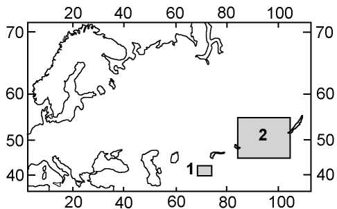
Materials and methods. The present work reviews the results of exploration works using modern technologies of basin analysis and numerical basin modelling. A structural-tectonic model of the East Arctic sedimentary basin was developed using the structural representations of the 1:5,000,000 scale performed by VSEGEI specialists in 2014. The developed model includes four main sedimentary complexes: pre-Aptian, Apt-Upper Cretaceous, Paleogene and Neogene-Quaternary. The modelling strategy was determined by the geological structure and evolution features of the sedimentary basin under study, as well as by the quality of available geological, geophysical and geochemical information. The East Arctic water areas were combined into a single model, since their sedimentary basins are part of the same continental margin and their boundaries do not always coincide with the conventional boundaries.
Results. On the basis of the conducted analysis of initial data, we developed a structural-tectonic model of the East Siberian and Chukchi Seas, as well as their surrounding areas. This model describes the distribution of the main structural elements, their spatial relationships, as well as their regional hierarchical nomenclature. The developed model includes four main sedimentary complexes: pre-Aptian, Apt-Upper Cretaceous, Paleogene, and Neogene-Quaternary. The structural model covering the aquatic areas of the Laptev Sea, East Siberian and Chukchi Seas includes five main surfaces: the basement of the sedimentary cover; the Pre-Aptian unconformity; the Cenozoic base; the unconformity in the lower part of the Oligocene and the basement of the Quaternary sediments; as well as the modern bottom topography.
Conclusion. Using the technology of basin modelling, a structural-tectonic model of the basement and sedimentary cover of East Arctic water areas was created, which can be used for planning exploration works.
GEOLOGY AND PROSPECTING FOR SOLID MINERAL DEPOSITS

concentration. According to the conducted mineralogical and chemical analysis, the highest concentrations of useful components were determined at two depth levels of 60—85 and 125—160 m within the limits of the most productive north-eastern and south-western flanks of the deposit.

In a quasistatic simulation of a single explosion leading to rock destruction, the nature of the propagation of radial cracks in the rock resulting from the pressure of the shock wave, detonation products, and stress concentration in the vicinity of the crack tips was revealed. Moreover, the growth of cracks in granite due the explosion occurs within 15 ms, and in limestone within 20—25 ms, depending on the physicomechanical properties of rocks, their degree of fracturing, and the use of a special type of tamping. The operating principle of the locking tamping is based on the reflection of shock waves from the internal funnel-shaped profile, as a result of which a partial detonation of the detonation products occurs. Tamping retention in the borehole is maintained due to its expansion by detonation products.
From the analysed studies conducted in laboratory conditions, the strength of ore limestone and magnetite samples after a single explosive loading was found to decrease by 38.6 and 40.8% of the initial static compressive strength, respectively, and after repeated exposure, on average, 5-10%. The dimensions of the zone of reduced strength in the surrounding massif was found to be dependent on the height of the quarry ledge and the energy characteristics of applied explosives.

MINERALOGY, PETROGRAPHY, LITHOLOGY

The main reef builders during the Early Cambrian were archaeocyatha and epiphytaceans, while Ordovician reefs were created by sponges, stromatoporoids, tabulata and bryozoans. Stromatoporoid, tabulata, rugose and, to a lesser extent, bryozoans were the reef builders during the longest Silurian-Devonian period. Bryozoans and corals served as the frame-forming organisms for Upper Viséan-Serpukhovian reefs. However, during the Permian, reefs were built primarily by sponges and, to a lesser extent, by bryozoans and corals.
It is shown that there is no strict correspondence between the termination of reef formation and the beginning of extinction events. During extinction periods, potential reef builders did exist, although beyond the reef biocoenosis structure. Similarly, the beginning of reef formation occurs somewhat later than the appearance of the corresponding frame-forming organisms. Apparently, it takes time for organisms to develop such a biocoenosis that could trigger the formation of reef ecosystems. Reef ecosystems are stable under relatively constant external conditions, changes in which cause first the degradation of the biocoenosis and then the extinction of its constituent organisms. Therefore, the process of reef formation is terminated before the actual extinction of organisms.

Background. The majority of the world’s deserts were formed within the valleys and coasts of ancient alluvial rivers and lakes. The material carried across many hundreds and thousands of kilometres by the wind was mixing with sediments of various genetic types. In addition, due to the similar physical nature of the wind and water transport of sediments, the recognition of the aeolian environment can be problematic.
Aim. Using innovative research approaches, to provide a qualitative structural description of sands; to identify and characterize factors contributing to the formation and preservation of a ferruginous film on grains; to establish the genesis of the transferred sediments, as well as the relationship with the parent rocks.
Materials and methods. Samples for analysis were collected from aeolian deposits in three deserts: Rub al Khali (United Arab Emirates), Nubian desert (Egypt) and Grand Erg Oriental (Algeria). Particle size analysis was used to characterize samples in terms of three parameters (length, width, thickness). X-ray diffraction analysis was carried out using an ARL X’tra diffractometer (Switzerland). The collected samples were also studied using a binocular microscope in reflected light and a scanning electron microscope.
Results. The mineral composition of the sands under study was examined. The graphs (histograms) of the size distribution of quartz grains (being the most common sand mineral in terms of size and frequency of occurrence) were plotted. The shape and nature of the grain surface were analysed.
Conclusion. The frosting on aeolian sand grains can result not only from micro-cracking as the most common sign of wind transfer, but also from the presence of a calcite film on grains. Factors contributing to the formation and preservation of a ferruginous film (desert varnish) were identified. The conditions for the formation of aeolian sands, as well as the genesis of such sand sediments, were established.

Background. Clarification of the structure of sedimentary formations located on the Siberian Platform by means of lithological and petrographic core studies has a theoretical and practical significance for the creation of geological models for oil and gas prospecting and exploration works.
Aim. To characterize and compare the composition of the upper Vendian of the central and southern parts of the Prilensk-Nepsky structural-facies zone.
Materials and methods. Core samples for analysis were obtained from boreholes in the Preobrazhenskaya, Verkhnechenskaya, Danilovskaya, Yaraktinskaya and other areas. The article is based on the results of a layered lithological description of the cores from 15 wells with a total core output of 560 m in the interval of the Nepsky and Tirsky formations; the petrographic analysis of 540 thin sections; the determination of grain size distribution of rocks by laser light scattering in 220 samples; and X-ray diffraction analysis of 540 samples.
Results. The Nepsky formation is represented by the following lithotypes: conglomerates, gravelites, sandstones, aleurolites and argillites. The section of the southern part of the structural-facies zone, compared to its central part, is characterised by increased claying. This is associated with the location of this zone in transitional coastal-marine environments, where large river systems were discharged carrying sandy-clay material into the basin. The source of the terrigenous rocks was felsic igneous rocks. The section of the Tirsky formation of the central part is represented (from bottom to top) by a transition from argillites and aleurolites to dolomites. In the section of the southern part, basal sandstones lie at the base, alternating upstream with clay-carbonate rocks.
Conclusion. The material composition of the studied sediments reflects the specifics of sedimentation during the Nepsky and Tirsky time periods. For the first time, the Tirsky formation of the southern part of the structural-facies zone was divided into four lithological members. The formation of basal sandy rocks at the bottom of the sub-formations is associated with the stages of tectonic activity and positive tectonic movements that initiated relatively rapid weathering and transportation of terrigenous material from adjacent heights to the sedimentation basin.
GEOECOLOGY


ISSN 2618-8708 (Online)


